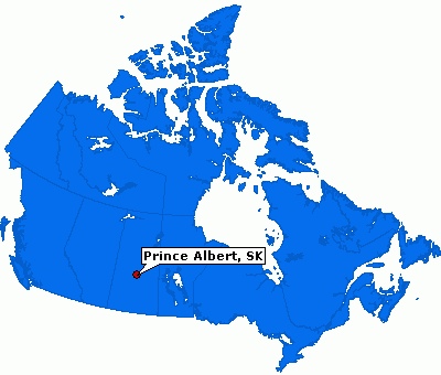
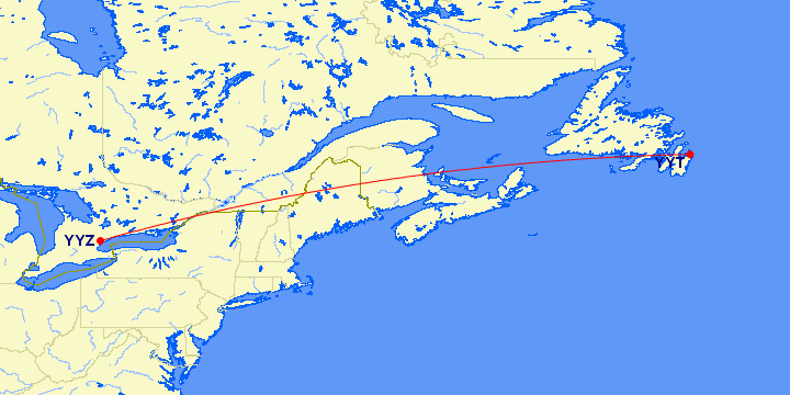
I was out to Prince Albert, SK for a quick meeting on a couple of our new sites with Public Works and the engineering consultants. Flew out Tuesday morning, drove to PA and then back to Saskatoon for a return flight the next day. Ended the year with 38 flight segments and 39K qualifying flight miles, good for another year of Air Canada Elite 35K.
Park City, Utah
I spent the week in Park City, Utah for the NADP Fall meeting. The turnout wasn’t great as many of the usual participants are Federal employees from the EPA, USGS and NPS. Park City is about 40 miles east of Salt Lake City.
The fall colours were quite nice as you drove in from Salt Lake City. This was the view from my hotel room.
Park City hosted a number of events during the 2002 Winter Olympics, including, alpine, slalom, aerial, snowboarding and ski jumping.
At Least They Use the Crosswalks
After breakfast we headed over to the Land Registry office in Kenora to find some land owner information. As we pulled up to one of the major streets there was some four legged pedestrians causing heads to turn. This pair of doe and buck started in between the crosswalk lines when they started to cross the street.
They stopped for a few leaves.
Checked out the Boston Pizza window.
And then headed back onto the street.
Made a few cars wait while they decided to cross again.
We drove over a 1000 km’s on northern Ontario back roads and didn’t see one sign of wildlife. Now realize you don’t have to leave the town, they’ll come to you.
Then they finished with some flowers from the bed in front of the ServiceOntario building.
My drive over two days. A. Winnipeg, B. Kenora, C. McIntosh, D. Quibell, E. Vermillion Bay, F. Kenora, G. Grassy Narrows, H. Winnipeg
Newfoundland 2013 Summary
Number of days on The Rock: 13
Number of digital photos taken: 1,221
Number of kilometres flown: 4,277
Number of kilometres driven: 2,668
Most kilometres driven in one day: 652
Number of relatives visited: 0
Number of ferries taken: 2
Number of provinces visited: 2 (stopover in Halifax going)
Price of most expensive gas: $1.429/litre (2013-07-20) in Gander, Newfoundland
Price of cheapest gas: $1.314/litre (2013-07-22) in St. John’s, Newfoundland
Price of gasoline for trip: $370.91
Number of pounds of lobsters consumed (family): 10.92
Taking the girls to Newfoundland for sea kayaking, whale watching and walking on the earth’s mantle : Priceless
A map of some of the trip points of interest and gas prices around the province.
Day 13: Heading Home
Our last day in Newfoundland started like our first with the sun shining and temperatures in the 20’s. We headed out to the airport and the Maple Leaf Lounge for some lunch. Claudia waiting for the soup to be ready.
Angela playing her DS.
A Canadian North plane heading for Winnipeg.
At times Gillian seemed to be more excited about the lounge than the trip.
Our plane arriving on time.
Our flight today.
Gillian and Angela on the plane. Angela had the devil child sitting behind her.
We arrived back in Toronto on time, our bags were slow coming out, but it did allow us to watch the news that the Royal baby had arrived. We used the valet Park’N Fly on this trip and that worked out well. After dinner we headed out to Carolyn and Danny’s to pick up Chloe. She was as excited to see us as we were to see her. A big shout out to Carolyn, Danny, Alex and Emi for looking after Chloe. I’ll do a trip summary and post some more videos that we took over the two weeks. Thanks for following along on our epic adventure.
Day 12: St. John’s and Area
Our last full day in Newfoundland was spent in St. John’s. We woke to overcast skies and some thunder, but by 10:00 the sun came out for the day. We headed for Signal Hill National Historic Site. There is a new Visitor Centre (at least new in the sense that it wasn’t there when Susan and I were here in 2001). The Signal Hill Tattoo do a re-enactment of garrison life in the late 1790’s. We didn’t stick around to watch the show ($5/head). It looked like the soldiers were waiting for the bus.
These guys were studying their cheat notes before the show.
Cabot Tower at the top of Signal Hill. It was completed in 1900 and in 1901 Marconi received the first trans-Atlantic wireless message.
Angela listening to what Marconi heard, sort of, it was out of order.
On top of the tower the winds were strong, like everywhere else in Newfoundland.
Claudia holding the door for people.
Gillian standing guard.
Even though the hill was busy, if you wait long enough you can still get a photo of the tower without any tourists in the frame.
Some of the re-enactment.
Claudia atop the Queens Battery canons.
A colourful view of downtown St John’s. The Basilica of St John the Baptist is in the top right.
The girls on the canon.
Angela checking for canon balls.
In front of St John’s.
From Signal Hill it was on to Cape Spear National Historic Site.
There were some fin whales off the coast.
Cape Spear is the most easterly point in North America. The girls have now been to the far east of Canada and the far south (Pelee Island).
Once again the day’s weather forecast was right on.
Claudia atop one of the WWII coastal defence gun battery.
Angela surrendering.
This lighthouse was built in 1955 to replace the original lighthouse.
They have restored the original lighthouse built in 1836. This was the second lighthouse to be built in Newfoundland.
Claudia holding the lighthouse.
From Cape Spear it was back to downtown St John’s to walk around.
St John’s colourful houses.
Being a Sunday we attempted to go to church. We walked up the hill to The Basilica of St John the Baptist, unfortunately the doors were locked. The church was constructed in 1841.
So we sat on the steps and enjoyed the view.
The Gower Street United Church. It was completed in 1896.
The Masonic Temple built in 1894.
The court house on Duckworth St. It was built between 1899-1901, it also housed the public gallows.
Some of the colourful exteriors of the stores along Duckworth St.
Another mermaid near a chocolate store. The one in Twillingate was also beside a chocolate store.
Colourful and hilly.
Claudia resting outside one of the stores while the others were shopping.
Gill’s unders the Gill’s Cove sign.
The girls with a Newfoundland dog statue.
When the girls were younger, they would make boobie traps on the beach, we came across this store on Water St.
One of the stairways going from Duckworth down to Water streets.
We enjoyed the walk around downtown.
Our drive today. A. Hotel B. Signal hill C. Cape Spear D. Downtown, St John’s
Day 11: Out of the Way Puffin Viewing
Saturday we checked out of our Old Salt Box Co. house. We had enjoyed our stay at Evelyn’s house in Herring Neck. We would definitely return or try another of the homes.
The girls enjoyed the straight staircase.
The girls out front.
Our final destination was St John’s, but I suggested we head to Elliston on the Bonavista Peninsula. Elliston use to be called Bird Island Cove because of a couple of islands that are close to land that were popular nesting areas for seabirds. Elliston has one of the closest land views of puffins with hundreds of nesting pairs. Here are the girls heading for the puffin viewing.
There were a few puffins on the land side.
This guy was collecting materials for his nest.
We got amazing views of the puffins up close.
I sat in the grass and one kept walking closer and closer.
There were hundreds of puffins. In the background you can see the other puffins on the island.
Angela trying to get up close and personal with a puffin.
Claudia doing the same.
It was just as cool to watch them take off and land.
These guys were on the island side.
The island full of puffins.
It was an amazing experience, we didn’t know what to expect when we got there, there was no way we thought we would get that close to them.
There was a puffin muskoka chair near the road.
If you ever get to Elliston, drop by the puffin viewing site. This week was also the Elliston Puffin Festival at the Municipal Grounds.
Elliston is known as the “Root Cellar” Capital of the World. There were a couple that were open that you could walk into.
The inside of the root cellar.
Just drive around and you’ll see them in the sides of the hills along the roads or near the houses.
We made a quick stop in Trinity. Trinity is one of the most notable “heritage communities” in the province.
Todays drive. A. Herring Neck B. Elliston C. Bonavista D. Trinity E. St John’s
Day 10: Twillingate
The view for our morning coffee.
Today was shaping up to be a good weather day.
Our Salt Box home.
After some early cloud cover the sun was starting to peak out.
The scenery never gets old. It’s like being in the Newfoundland and Labrador television commercials.
We headed to Twillingate to do a whale watching tour.
We drove around to kill some time before the tour.
Claudia looking over to Twillingate South.
The Tanabe’s in Twillingate.
On the dock with the mermaid. The Mermaids in the City ran in St John’s in 2006. Kind of like the moose in Toronto.
Heading out hoping to see some whales. There were no icebergs around.
Burnt Island.
The Longpoint Lighthouse.
Early on there were no sightings.
And then we saw a minke whale.
And followed it around.
Then there were three fin whales.
The fin whales are up to 23 m in length.
The girls were happy to see the whales.
The weather was perfect. What a difference from yesterday.
Angela and Gillian looking at her pictures. (I got heck from the girls for originally captioning this as “Angela and Claudia”)
After a couple of hours we headed back for shore.
The girls back in Twillingate.
That was our boat.
We took the drive out to Crow Head and the Long Point lighthouse. Looking down at the waves crashing the rocks.
Angela at the edge.
The lighthouse was built in 1875.
Claudia holding up the lighthouse.
The girls goofing around.
Another “I thought we were done with these…” photos.
St Peter’s Anglican Church is one of the oldest wooden churches in Newfoundland. It was completed for 1844.
We took in the Durrell Museum.
The polar bear that came to Twillingate in 2000 on the ice. It had to be destroyed and was eventually returned to the town for tourism purposes.
At the end of the road was French Beach. There was a run of capelin, the black in the water.
Some rocks to climb around on.
This local boy was catching the capelin with his net.
Angela giving Mom fits.
There was a pet cemetery.
We found some root cellars.
One of the boat house across the road from our house.
We took a drive to Merrit’s Harbour. Here is Claudia hanging from the cliff.
Claudia managed to climb back up.
A root cellar in Herring Neck.
The end of day.
Our drive today. A. Herring Neck B. Twillingate C. Crow Head D. Merrit’s Harbour
Day 6: Tablelands
Today we headed to the Parks Canada Discovery Centre and then the Tablelands trail. The Tablelands are a geologic wonder. It’s ultramafic rock (peridotite) that makes the Tablelands so barren. The Tablelands is one of the few places in the world where you can see exposed earth’s mantle. The rock was forced up to the surface millions of years ago during a plate collision, and peridotite lacks the nutrients which allow plants to grow.
The hike was an easy 2 km to the end of the trail.
The girls on the Tablelands.
Even though the skies were looking funky, the rain held off all day, it wasn’t until we were driving back to the cottage that it started to shower, which was odd since that is when the sun finally appeared.
The wind on this trail was amazing.
Parts of it are boardwalk.
There is still some runoff coming down.
Claudia with her walking stick. She has been carting it around Gros Morne.
After this photo, the girls and I decided to see how far we could climb up.
Up we go.
The little white patch in the lower centre of the photo is where we left Susan.
Angela and Claudia up ahead.
Angela and Claudia waiting for Gillian.
The views are amazing.
Waving to Mom.
Time to head down.
Me on the Tablelands.
Some of the rare flora growing on the Tablelands.
These bushes are growing on top of the rock.
Look close and you can see an ant on the right clump of flowers.
Some moss just growing on top.
Heading back to the parking lot.
Another waterfall, Angela and I walked up to the base of the falls.
Angela crossing the stream.
Angela touching the waterfalls.
This rock had a face on it.
Across the highway it is lush and green.
It was a great walk through the Tablelands.
We headed down to Trout River for a picnic lunch.
Trout River Pond.
The girls hanging around.
Trout River is a small rural fishing village originally settled in 1815.
We walked up to see the Old Man Lookout.
It overlooks the village.
We saw the beach and that was our next stop.
Another beach with sea glass.
Heading back to the cottage along Route 431, it shows the difference between the two sides of the highway.
We found some green chairs at the Tablelands lookout.
Just before the rain showers started on the South Arm.
After dinner we headed down to Middle Brook.
Further up brook was a larger set of waterfalls.
The evening view out our cottage window.
Our drive today. A. Glenburnie B. Tablelands C. Trout River
Day 5: Sea Kayaking
Today we packed up from our first cottage and headed to Norris Point to do a sea kayaking tour with Gros Morne Adventures. The guided tour was 2 hours and goes out onto Bonne Bay.
The girls investigating a dead jellyfish, some things haven’t changed.
The girls getting instructions.
The kayaks were setup so the person in the back had to steer with their feet.
Angela was steering for her and Gillian.
I was in a single.
Susan and Claudia looking for sea life.
There were lots of jellyfish in the water.
Gillian and Angela working out their differences.
More jellyfish.
The weather was great, a little overcast when we started and then the sun came out.
An ugly fish.
Back on our way along the coast.
A juvenile bald eagle that we followed down the bay.
A freshwater waterfall flowing into the bay.
We saw a river otter down near the falls.
There was another bald eagle that we saw on our way back.
Overlooking Norris Point.
When we got back on the Viking Trail we saw our first moose. It was at the side of the road, and it started walking along the side before going down a side road and disappeared.
We headed back to Deer Lake to get some groceries before heading to our second cottage in the south end of the park.
Angela thought we were done with these types of photos.
After dinner we headed out for a drive to Woody Point.
The lighthouse, built in 1959, the original lighthouse was first built in 1919.
Looking down the South Arm.
We are staying at the Middle Brook Cottages in Glenburnie.
This is Middle Brook.
The brook is located next to the cottages. This is an old bridge, the newer bridge is in the distance.
Angela getting her feet wet.
Gillian taking pictures of the brook.
Todays drive. A. Rocky Harbour B. Norris Point C. Deer Lake D. Glenburnie
Archives
Search
Tags
airport angela backyard baseball beach big things birds birthday blue jays capmon chloe christmas claudia curling driving family free germany gillian guiding hockey jamaica japan lighthouse maps mcmaster movies nadp newfoundland nova scotia outdoors outings pei riu saskatchewan school skating soccer tamzooka uncle tak university video wildlife wisconsin workPages
Links
Meta